Archaeologists are often pictured in remote places, far from the modern world, excavating the remains of a ruined structure. While this might be true (certainly more accurate than any fictional character armed with a gun or one who is running away from mummies) it is not always the case. Fieldwork takes up a small fraction of our projects and many of us are often behind our computers, studying artifacts in museum collections, working in the laboratory, the library, or in archives.
With the help of modern technology and tools used in digital humanities, we can do a lot more with the data –– most importantly, we can share the data and make it publicly accessible. Mapping is one of the powerful tools we can use, especially when it can tell a story. As part of my doctoral dissertation, I am building a map of fertility shrines in North Lebanon, because the sites I am studying have never been mapped. Moreover, I want the map to be more than a documentation of their locations. My goal is to make it publicly accessible so it can tell stories shared by the local community.
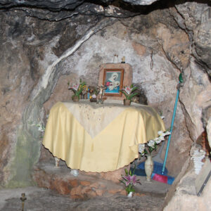
Fertlity shrines are mostly caves or grottoes dedicated to saints that women visit to seek help in issues of fertility, lactation, and infant health. In the summer of 2022, thanks to the Early Research Initiative (ERI)/PublicsLab Summer Research Fellowship, I was able to survey over thirty shrines for my dissertation. They were very difficult to find as they are typically in remote places, away from the village center.
Fertility shrines are locally known by names such as “Our Lady of the Breasts” or “Our Lady of Lactation,” as many of them have natural rock formations resembling breasts, from which water drips. During my fieldwork, it became clear to me that these understated spaces have a much larger role in the country’s religious and cultural heritage. Although they are not as popular as they once were, they have been used by women since recorded history, if not earlier, and certainly before the advent of Judaism, Islam, or Christianity.
With the advent of the three dominant monotheistic religions, women did not abandon their ancient traditions of visiting these shrines, although many religious leaders objected to them. What is even more remarkable is that people of all religions shared these shrines, which scholars today call “shared” or “mixed” shrines. Sharing a sacred space was once very common; however today, issues caused by colonialism, geopolitics, and sectarianism are making this much rarer. What was a shared space by Muslims, Druzes, Jews, Christians, and Pagans now belongs to one group, as many of these places are witnessing a religious conversion to a single religion.
Because they have always been independent from official places of worship such as churches and mosques, and because they are associated with popular religion, and specifically with women, the fertility shrines are largely missing from historical records, archaeological studies, and even historical or modern maps. Only two shrines had road signs directing visitors and less than five were pinpointed on Google Maps by a local guide, but the coordinates were not always accurate. To be able to find them, I had to stop and ask for directions. As a stranger asking for a place called “Our Lady of the Breasts”, I got one of two reactions: women smiled, then realizing I might be going to fulfill a vow wished me a blessed visit and healing. Men were in general too uncomfortable with my question, and preferred that I ask a woman.
Making a map became crucial to my project mainly because it is useful for me to see the cluster of shrines while analyzing the landscape and the network of these shrines. But the map can also serve a purpose beyond my academic work as these places must be documented and their location published for anyone who wishes to visit or simply to learn more about them. Additionally, the map can serve as a repository of the shrines’ oral history, built to tell the stories of these places and the miracles they produced. My plan is to make the map available online and accessible to everyone who wishes to learn more about healing shrines and to those who would like to add more information about them. It is still a work in progress, and is now available on Google Maps.
The ultimate goal is to preserve a shared heritage at risk of disappearing. In a country where sectarianism is an integral part of the political system and part of everyday life, shared sacred spaces have been gradually disappearing. Spaces of healing and prayer are being appropriated and converted by one religious group, transforming the entire sacred landscape of the region into sites of contestation. This is nowhere more observable than the Holy Land and Istanbul, where we are witnessing the conversion of shared sacred spaces into monoreligous spaces. By preserving this shared heritage while it’s still available and accessible, I am hoping that this map with its crowdsourced information will further help protect these mulitfaith shrines so they become resilient to sectarianism.
 Sarah Mady is a Ph.D. Candidate in archaeology at the Graduate Center of the City University of New York. She is an adjunct lecturer at Montclair State University, NJ, and Fordham University, NY. Her research is focused on healing shrines in North Lebanon that specialize in fertility, lactation, and infant health. Such spaces have been active since Late Antiquity and used by women and mothers of different faiths. Her other research interests include the history of archaeology in Lebanon, the intersection of politics and archaeology, and the religious and cultural heritage of Lebanon among other topics.

This entry is licensed under a Creative Commons Attribution-NonCommercial-ShareAlike 4.0 International license.